Ten Minute Tuesday - 3D Modeling from end to end!
Our latest video - 3D modeling from end to end.
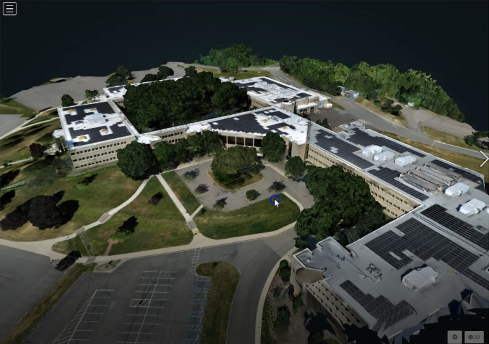
This covers everything from using Dronelink to capture the images all the way through to processing and viewing the 3D model.
Here's a link to the video: https://vimeo.com/728947826
Normally, I like to keep these to 5 minutes or less. But...I couldn't do that this time so instead of a Five Minute Friday, we have a Ten Minute Tuesday!!
The component used in this video can be found here in case you would like to use that as a starting point:
If you would like to use WebODM lightening here is a link to that https://webodm.net/uav_mapping/19634
And if you would like to use the WebODM Installer for PC and Mac, here is a link to the download area https://www.opendronemap.org/webodm/download/
This is my first time doing a Ten Minute Tuesday - I'd love to have your feedback!
Comments
17 comments
Barry,
I hesitate between WebODM and Reality Capture. In case you know both, what would you recommend ?
Is there a way to publish the obj file.? for example on a website? I tried WordPress, but did not very good results so far.
You can publish to sketchfab. Free accounts are public though.
Good one Barry Houldsworth, I've been playing with this myself my results aren't as good as yours, but webodm is so easy to use, I'll take a look at your component as I've windmill I'd like to try and model
Martin Reading
Nice! Let me know how it goes.
Johank
There is an export option in WebODM that will allow you to take the files elsewhere, but you do need some sort of software to be able to view it. As Ken mentioned, you can use Sketchfab. Maybe give that a shot and see if it does what you need?
I know Sketchfab, but I want to be able to choose between public and private. And of course as cheap as possible. It is a hobby after all.
Johank
Sean Herd-Hoare
I saw you had a post that seemed to be asking how to do this - thought you might like to check it out,
I had someone reach out and share this video, with I thought added some interesting additional information that I didn't cover in my video https://www.youtube.com/watch?v=c4exnAcFNJM
Hi Barry,
Thank you for the video. It helped me.
I’m pretty new to drone piloting, and am quite concerned that I stay compliant. One question, therefore: you sensibly recommend flying the mission on an overcast day, in order to get diffuse light and avoid shadows.
However 107.51(d)(2) prohibits flying a drone within 2000 feet horizontally from a cloud. So that sounds like one is prohibited from flying a drone on an overcast day, period. Unless one has a waiver.
Am I reading the rules correctly?
Bradley Hall
This is all about VFR rules. You do need to stay at least 500ft below a cloud. But the 2,000ft really only applies if the cloud is low down. If the cloud is at the same level as the drone, then you need to be at least 2,000ft away from it.
But, if the cloud base is above you at 700ft then you can still fly, but only up to 200 feet.
Think about it this way. If the cloud base is 20,000ft, but it is directly above you, does it really make sense for you not to fly? And if the clouds had to be that far away, why did the FAA mention how far below you had to be?
Hope that helps
Thank you for the prompt response! Yes it helps, and it is good to be in touch with an expert. So far I have been learning drone piloting on my own.
Yes that does make sense. I suspected it was the case.
The rule is written as “and”, however I figured it really meant “or.” That is, the drone must be either at least 500 feet under the cloud, or at least 2000 feet distant from it horizontally.
My understanding is that there is a risk of aircraft flying out of the cloud and coming dangerously close to the drone.
I want to be careful in the extreme. I want to follow the rules, not cause any damage or put anyone in danger…and I want to have proper liability insurance. I’ve made it this far in life with a clean record all around and I want to keep it that way.
Let me introduce myself: I am from Millburn, NJ, so I recognized your mapping missions of northern NJ. I earned my part 107 certification about one year ago. Right now I learn using a DJI Mini 3 Pro and a DJI RC Pro controller.
I am retired from a career working internationally (UK & Japan) for big name Wall Street firms as a Project Manager in electronic trading systems.
I decided to learn drone mapping because of my involvement in disaster relief and at the Presby Memorial Iris Garden in Montclair. I recently learned how to use ArcGIS Online and migrated Presby’s legacy (non-GIS) curator’s database to it, with some exciting possibilities. This spring my objective is to add daily orthomosaic layers to the map of Presby, tracking the progression of bloom season. I believe I now have all the tools to do that.
I soon return to NJ for Thanksgiving and to prove my concept at Presby. While I am in NJ I would love to chat by phone or even drop by (either early December, or more realistically in the spring). I would appreciate being exposed to a day in the life of a professional. I want to explore using the skills am developing in a professional role.
In the meantime I am in southern Italy. I came here because it is an inexpensive, quiet place for me to concentrate on leveling-up my drone skills.
For eye candy I share a video I recently made of the town I am staying in. The subject matter around here makes for pretty content.
Thanks again
https://www.instagram.com/reel/CzQisXMKTGo/?igshid=ODhhZWM5NmIwOQ==
Nice one Bradley Hall
Thank you, Martin!
Pleased to meet you!
Nice place to visit - and nicely captured.
Barry Houldsworth
Thank you, and yes this is a nice place to visit.
I am a guest here through a chain of friendships that started with volunteering in disaster relief. Because the volunteering involved construction, I got to know some builders and architects who work internationally, and I must have made a good impression because I was welcomed here. It is a privilege.
I am staying in this hilltop village at a non-profit called “The Revolution of the Squid” (link below). The name refers to hands-on (tentacles on) experimentation, specifically in architecture and urban design.
As a result I have met and been befriended by some students and professors of architecture who were passing through. Some have given me hints at avenues to learn more about drone imaging. So I have a lot more to study.
https://larivoluzionedelleseppie.org/
Please sign in to leave a comment.