Altitude - Takeoff reference
Hi there
I was doing a mapping with an altitude at 17m the reference is takeoff location
Does that mean it takes 17m above the place i took off? cause my drone crashed into a tree
Hi there
I was doing a mapping with an altitude at 17m the reference is takeoff location
Does that mean it takes 17m above the place i took off? cause my drone crashed into a tree
<%= block.description %>
<% } %>
Comments
11 comments
Yes, that is what it means.
And what could the reason be for the drone crashing into the tree when running the mission?
See attached, sorry for my bad paint skills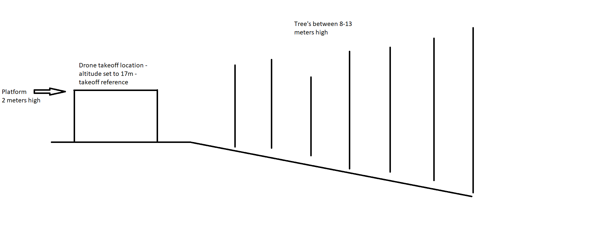
If you have trees that are 13 meters high then 17m is only a 12ft difference. That's not much - I usually leave at least 25ft.
Two things to consider.
a. Trees grow and, at this time of year, they grow fast.
b. The altitude is based on barometric pressure. If there was a change in pressure during the flight it could affect the altitude of the drone.
We measured the highest tree before recording, which was thirteen meters high.
And the takeoff position was already two meters higher, so it's around nineteen meters over the ground, and the ground is sloping downhill
I'm just trying to understand what i did wrong since six meters of clearance should easily be enough.
Verification mission first !
We never repeat it enough.
Verify as in simulation i presume
No. A verification mission runs the mission facing forward so that you can watch for problems and any collision avoidance can also work.
Oh, i did not know that. thank you, i do use a Mini 2 so that won't help anyway i guess.
The barometric altimeter on these drones is anything but exact and can drift several meters during a flight, If you are anywhere near obstacles we always recommend keeping your finger on the switch to take control in case of emergency.
I’m just curious to see the plan. Can you share it ? Also that altitude is very low for mapping but maybe you have a reason to run it very low. Also you can download the KMZ file and run it on Google Earth which will give you a better view. Enjoy.
Jim McAndrew good to know, i'm used to flying drones, but this is the first time i'm using a planning tool
The reason for the lower altitude was to get high res pictures of the crows next around the house, there a hundreds of crows in that area
link to plan https://app.dronelink.com/kwkn1910/my-first-project/plan/pgSRZAjb68NsLhkY9Bpv/8aBu9ZvAdbIT0buHXN2Z
Please sign in to leave a comment.