New flight pattern?
In search and rescue we use a pattern called the expanding square search, we're checking into it but we may be able to modify with an expanding circle .. would it be possible to somehow program an expanding cirle with a slight modification to an expanding 180 degree circle that we can use at the base of a mountain etc when it is more likely a survivor will climb down for help than up?
Comments
14 comments
Doug Fanning - Full disclosure, I know nothing about SAR and realize that those of you involved are dealing with life and death. Would something like this one work?
https://app.dronelink.com/southwestern-aerial-studios/tsimek-public/plan/CeHwrxPkmlqkwl2yAgAm
I tried to think ok, if where the mission plan begins a subjects last known position, and I wanted to scan going down the hill side, this would seem to give me good coverage. Love to learn your thoughts on gimbal settings etc. Just an idea.
Thanks Tony, that's similar to what we have planned to test right now but could be better. The expanding square has come from years of practice and refining so we can't stear too far from that. A programmable rounded grid map pattern that includes overlap settings and a 90 degree gimble could potentially be close to perfect
Thank you for explaining!! I wondered about the 90 degree gimbal because I would think looking straight down is a disadvantage when searching for somebody that may still be mobile. Well, you have practical experience so I trust your needs for the use case! It would be great to see a library of SAR appropriate missions that others could use if needed!
The Dronelink agl mapping will work very well for most applications. It's quick and easy enough for anyone of us to quickly grasp. I hear from others I've dealt with who have tried other software that in comparison Dronelink is the best option, i am biased but having owned Dronelink for 2 years I've recommended it because i agree with them. A contour search would also be a very useful tool
Some of our search patterns
https://owaysonline.com/iamsar-search-patterns/
I could see how the orbit could work. But, unlike the mapping component (which doesn't start in the middle and work out) I would worry that it would be too easy to create an orbit that doesn't correctly overlap.
The map does allow you to specify overlap but, as noted, doesn't start in the middle - just goes in a lawnmower pattern.
I know that DL allows scripting, so maybe that is an option to create what you need. But it's not something I've ever used. Wish I could help more.
It is a really interesting problem and request! Doug - thank you for sharing the link. This gives some perspective of why you do it certain ways.
Agreed on the orbit overlap and on the scripting. The orbit overlap can potentially be done correctly with a ton of testing/ guessing but currently it is one of our best options for this search pattern and better to be overflown than underflown. As volunteers we are not experts and the scripting will be way above most of our skill sets. One of Dronelinks strengths is point and click for dummies
It would be easy enough to create components with a number of partial orbits. As a component you could drop it where you need it and then use the transform handles to size/turn etc. to fit your needs. I'd still worry about the overlap but there might be a way around that.
Out of interest, how high do you typically fly these missions?
Our altitudes change depending on terrain. As we are 'mostly' looking straight down we won't be able to see obstacles coming, so agl is important, obstacle avoidance is important and if it's just trees we are from 120 feet to 150 but play better safe than sorry. The lower and slower the better.
For a flat field search we can cover more ground quicker at a higher altitude with less of an overlap but again the lower the better
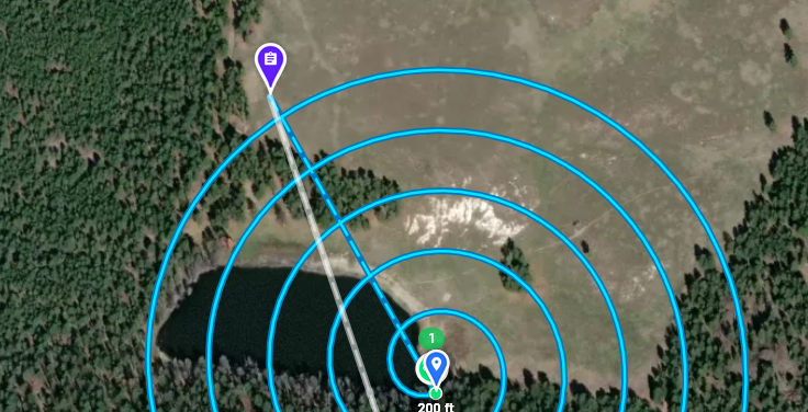
Something like this Doug?
https://app.dronelink.com/southwestern-aerial-studios/tsimek-public/plan/ib0lArq3JgKf0fcqbplU
Don't worry, I won't keep trying. : ) I think you are in the right place to get DL staff to look at a proper feature request. But you have me interested in what works.
As per Barry's suggestion i was just going to sit down and try that myself but yes Tony exactly like that but with overlap control. How long did that take you? Short and sweet .. with practice shorter and sweeter?
Cheers
Not long at all. But I realized I made a few mistakes. Something like this handles the drone heading better.
https://app.dronelink.com/southwestern-aerial-studios/tsimek-public/plan/ZocvtTIoHwdWEZfrX2F1
New patterns for Map have been on the list for a while (spiral out, linear / corridor, etc).
Just found this https://www.youtube.com/watch?v=6_g8oMRpUb8
Please sign in to leave a comment.